
A fact sheet to support the Soil CRC’s ‘Soil pits and data (Qld)’ webinar, delivered as part of our ‘Building technical capacity for improved soil management’ webinar series.
In this webinar, Dr Andrew Biggs from Resources Queensland guides viewers through:
- how to characterise a soil pit, including planning, supporting resources, and techniques for characterising different soil horizons
- how to access online soil data for Queensland.
Purpose of the soil pit
Soil pits can serve as either a focal point for discussion or a tool to facilitate conversations about soil characteristics and management. It’s important to be selective in what is discussed in the pit to keep the audience engaged and ensure effective communication. The purpose of the soil pit will determine where it should be located in the landscape and within the paddock.
A wedge-shaped pit is recommended because is mechanically efficient, safer, easy to access, and offers good visibility for multiple observers. The design accommodates variations in sun angle during the day, making it a practical choice.
Don’t forget to dial before you dig to locate and avoid services.
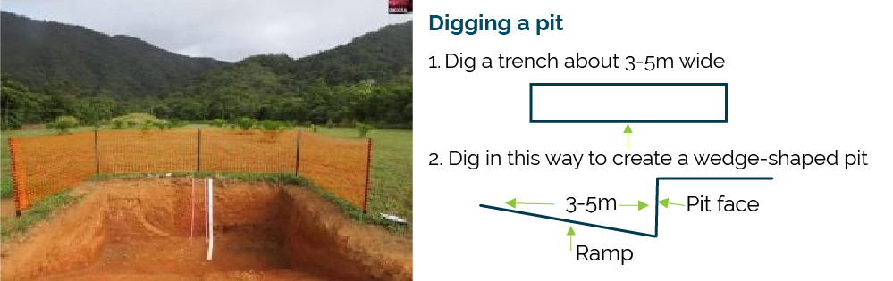
Digging a pit (Source: Andrew Biggs, Department of Resources, Qld)
Engaging your audience
What demonstrations or activities will you focus on? Involve the audience as much as possible in the soil assessments so they gain soil characterisation skills that will help them understand their own soils. Guides like the NSW Northern Rivers Soil Health Card were developed as a practical tool that landholders can use to monitor the health of their soils. The core of the card has a list of 10 straightforward visual tests that require simple equipment and can be carried out by one person in the field.
Accessing soil information in Queensland
When conducting soil pit activities in Queensland, it’s advisable to collaborate with local soil experts. The Department of Resources in Queensland employs experts who can provide valuable support for soil analysis. Queensland’s approach to soil information differs from New South Wales, and the availability of data depends on your specific location. Expert collaboration is a key strategy for success.
Scale of soil data in Queensland
In Queensland, soil data comes in various scales, from land systems mapping at 1:500,000 to more detailed 1:100,000 soils mapping. However, even at the 1:100,000 scale, maps may not provide precise information about what is in a specific location.
Be aware that what is represented on the map may not match the actual soil composition on the ground. Therefore, it’s important to exercise caution when relying on existing soil maps and consider that the dominant soil type in a map unit might not represent the entire picture, making on-ground soil assessments crucial.
The available information includes reports, technical publications, maps, and digital data accessible through web portals, covering land systems and soil mapping. Land systems are extensive, while soil mapping is primarily focused on major cropping areas.
To access soil information in Queensland, you can use the Queensland Globe spatial web portal, which hosts a range of geoscientific information, including point data for site descriptions and polygonal data for mapping. The Queensland government library catalogue also contains PDF files of reports and maps. The Queensland Globe offers a user-friendly interface for exploring different layers and provides details about specific sites and their associated projects, such as research or surveys.
The role of soil maps as guides
Soil maps serve as guides rather than absolute representations of soil conditions. When planning to dig a soil pit, the decision should be based on the specific purpose of the pit, whether it’s for discussing soil properties, landscape context, or chemical properties.
It’s important to recognise that soil characteristics, including colour, can provide valuable information about the soil profile, making colour a useful starting point for understanding soil composition.
What to look at
The NSW Northern Rivers Soil Health Card referred to earlier was developed as a practical tool that landholders in the NSW Northern Rivers Region can use to monitor the health of their soils, and it can readily be used elsewhere. The core of the card has a list of 10 straightforward visual tests that require simple equipment and can be carried out by one person in the field.
- Ground cover
- Penetrometer
- Infiltrometer
- Diversity of soil life
- Root development
- Soil structure
- Aggregate stability
- Earthworms
- Soil pH
- Leaf colour
Also consider recording:
- Where is the profile in the landscape?
- Depth of profile or depth to a (perceived) root-limiting layer
- Soil colour
- Identify soil horizons or layers
- Texture of each layer – note ribbon length and feel
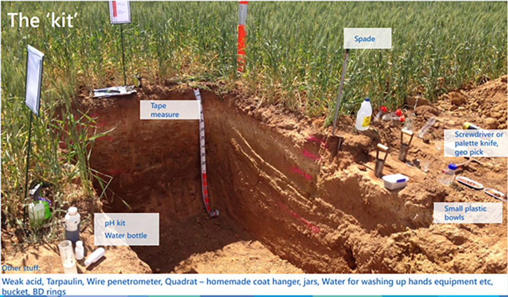
The ‘kit’ (Source: Abigail Jenkins)
Your soil pit kit
Here is a list of the equipment you’ll need to characterise soil using a soil pit:
- Tape measure
- Spade
- pH kit – pick up a pH kit at your local hardware store and use with a paint pallet tray
- Water bottle
- Screwdriver or palette knife
- Geo pick
- Small plastic bowls
- Weak acid
- Tarpaulin
- Wire penetrometer
- Quadrat – homemade using coat hanger
- Jars
- Water – for washing hands and equipment
- Bucket
- Bulk density (BD) rings
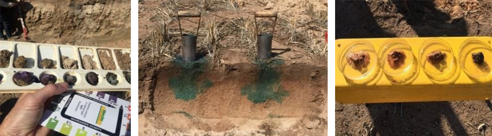
L-R: Field pH kit – Pick up a pH kit at your local hardware store and use a paint pallet tray; Infiltration demonstration – Use water-based paint and set this up the day before the event; Slaking and dispersion demonstration – use rainwater or de-ionised water and pop in a clod of soil (Source: Felicity Harrop)
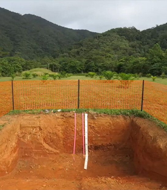
A soil pit (source: Andrew Biggs)
Related Soil CRC webinars
Further information
- Soil description – Australian Soil and Land Survey Field Handbook, CSIRO (’The Yellow Book’)
- Queensland Globe (Qld Government)
- Australian National Soil Information System
- Visualising Australasia’s Soils (VAS) – A Soil CRC Project
- Soil Pit Field Protocol
- Qld Soils email – soils@qld.gov.au
- Soil Science Australia smart soil resources
- Soil Basics videos (Purdue University)
Acknowledgement
This webinar was recorded in 2021 as part of the ‘Building technical capacity for improved soil management’ webinar series. It was produced by the Soil CRC and jointly funded through the Australian Government’s National Landcare Program.
Posted Apr 16, 2024