Key points
- Making Australasian soils data findable, accessible, interoperable and reusable (FAIR), provides a range of benefits for research, on-farm decision-making, and policy development.
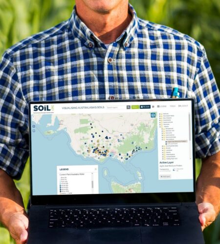
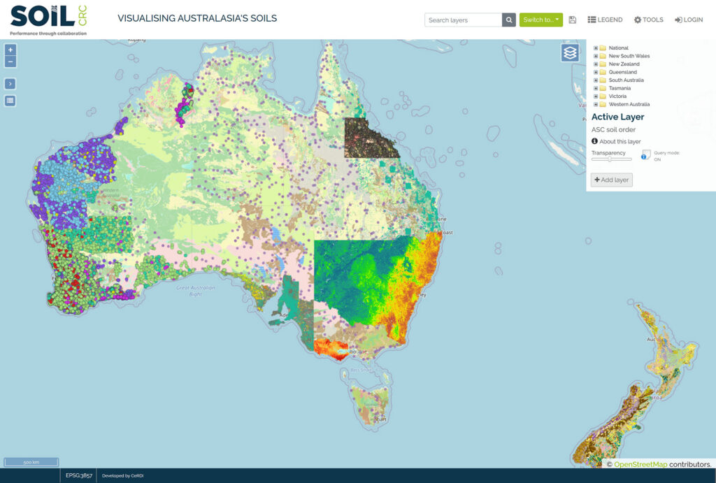
- The Visualising Australasia’s Soils (VAS) project is building a web-based portal that brings public and private soil data into one place, in a standardised format.
- Phase 2 delivered major improvements to VAS, including new data input templates, alignment with international standards, better data displays, and education resources for users.
- Soil data custodians recognise that sharing data leads to better decision-making and better tools, however, some custodians remain cautious about privacy, security and the time involved in contributing data.
The challenge
Soil data is held by many different custodians across Australasia, including farmer groups, catchment managers, government agencies, universities and private organisations. Each custodian has their own way of recording, storing and describing data. As a result, the data is hard to find and reuse.
Without a coordinated system for sharing soil data, opportunities for research, on-farm decision-making and policy development are lost. Decision support tools, machine learning applications and artificial intelligence models all rely on good quality, well-described, standardised data drawn from trusted sources.
Building the infrastructure to deliver this data, while respecting the rights of those who own and steward it, is an ongoing challenge in Australasian agriculture.
Our research
The Visualising Australasia’s Soils (VAS) project aims to make it easier to find and reuse Australasian soil data. The VAS portal allows participants to upload their data into secure, cloud-based infrastructure. The portal accepts soil data in many different formats and converts it into a standardised format. Custodians keep control over who can access their data and on what terms.
The first phase of the project (2.3.001) ran from July 2019 to June 2021 and delivered a web-based repository that brought together soil data held by public and private groups, so the data can be discovered and used through a single online portal.
Phase 2 of the project ran from July 2021 to July 2024, led by Federation University Australia in collaboration with the University of Newcastle, Southern Cross University, and Manaaki Whenua Landcare Research New Zealand. The project began with 21 industry participants, including 19 farmer groups and two catchment management authorities.
VAS improvements
Building on the architecture established in Phase 1, the project team upgraded the technology underpinning VAS and mapped soil data in VAS to international interoperability standards. Project partners worked with the team through co-design workshops and feedback to shape the data input templates, reporting tools and display features so that VAS meets the needs of those using it.
User research
It was important to design VAS with users in mind. Two rounds of semi-structured interviews were conducted with 14 industry partner organisations between 2022 and 2024. Interviews explored participants’ use of VAS, their perceptions of its functionality, and the challenges and opportunities of sharing soil data.
Research findings
VAS improvements
Phase 2 delivered improvements to VAS, including:
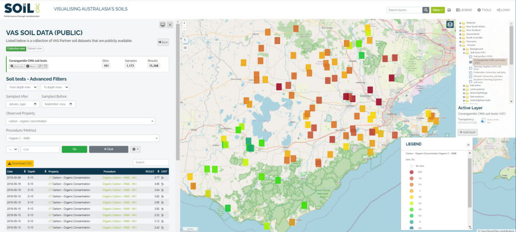
- New data input templates. The system now captures the details needed to make soil data findable and reusable, including ownership, licensing, project information, site and sample names, laboratory used, and analytical procedures. This reduces the back-and-forth previously required between the VAS team and data custodians to clarify these details.
- Alignment with international standards. Soil data in VAS now uses national and international soil terms, units, procedures and vocabularies, so it can be unambiguously understood and reused by other soil data systems around the world.
- Easier to view and understand data. The portal now shows a summary and basic statistics for each dataset, and new charts and graphs let participants explore their data visually.
- Education and literacy resources. New content pages, short instructional videos, user guides and educational tools are now built into the portal to help participants get the most out of VAS.
At the end of Phase 2 (July 2024), VAS held contributions from 11 farmer groups, four catchment managers and two universities. This amounts to 55 datasets, representing 3,043 sites with 10,919 samples on which there are 218,375 observations. These data span the period from 1988 to 2024. Soil moisture and temperature probe data from one farmer group adds a further 600 million observations.
User research
A key finding from the interviews was that data custodians will only share their data with VAS if they see clear value in return. For some participating farmer groups and catchment managers, that value is already clear. VAS provides access to a trusted, supported, web-based system for managing their soil data. For others, the value proposition is less certain. Participants voiced concerns about data security, the time required to upload data, and whether the VAS portal would endure beyond the life of the Soil CRC.
Significance of the findings
The project has shown that soil data held across the private and public sectors can be made FAIR. Most current soil data initiatives are run by government agencies and focus on public sector data. VAS is bringing together both public and private data across farmer groups, catchment managers, researchers and government.
VAS is one of very few projects building the practical infrastructure needed to deliver on the promise of digital agriculture. Soil data is what fuels modern decision support tools, including machine learning and artificial intelligence models that could benefit Australian agriculture.
Participating farmer groups and catchment managers now have access to a trusted, web-based system for managing their soil data in one place, aligned to international standards.
Researchers have access to well-described, structured, standardised and place-based data that can support new research.
The longer-term direction is for VAS to become the legacy of an Australian soil data federation, established by the Soil CRC as an ongoing component of a national and international soil data ecosystem. With it, Australian farmers, agricultural industries, researchers and governments have a growing body of soil and land data on which to base decisions, and the means to feed that data into the tools they already use for analysis and visualisation. Trusted soil data also provides evidence of soil stewardship, which is increasingly required for environmental compliance and sustainable development reporting.
Next steps
Phase 3 of the VAS project (2.3.003) commenced in August 2024 and will run to March 2027. The research will focus on transforming VAS from a research project into an enduring component of the Australian soil data ecosystem.
Priorities include establishing the governance framework, business case and value propositions required for a self-sustaining VAS that endures beyond the life of the Soil CRC.
Although participants accept in principle that better data leads to better decisions and supports soil stewardship reporting, these rewards have not yet been demonstrated in practice. Phase 3 will work with participants willing to pilot use cases that connect their soil data to existing tools such as calculators and decision support systems, so the practical value can be shown.
A further research priority is to explore the use of artificial intelligence tools that allow users to ask questions of the federated data in a way that maintains data privacy. Examples include using language models to answer common questions such as how much lime to apply, what the soil carbon gap is, or how much subsoil moisture a paddock will lose over the coming months.