A fact sheet to support the Soil CRC’s ‘Soil characterisation in WA’ webinar, delivered as part of our ‘Building technical capacity for improved soil management’ webinar series.
In this webinar, Murdoch University Professor, Dr Richard Bell, guidesus through the soil pit protocol and assessment process. Learn how to describe different soil types, their properties, and how they relate to agricultural production. This knowledge will be crucial for understanding the soil characteristics that are significant for soil management and plant growth.
Accessing The Data
Valuable data about specific soil types for their locality can be accessed from the reference material below, to provide insights into soil types and properties before conducting a soil pit analysis.
- Soil data – Australian National Soil Information System
- Visualising Australasia’s Soils (VAS) – A Soil CRC Project
- Western Australia – WA Soil and Land
- Soil description – Australian Soil and Land Survey Field Handbook (CSIRO)
- A Simple Guide for Describing Soil (DPIRD WA).
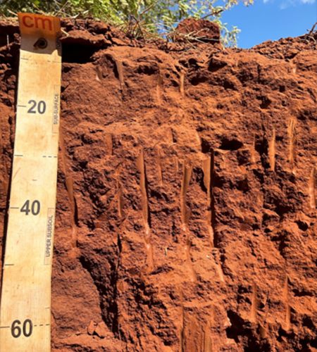
Soil Profile Analysis
Soil profile analysis involves assessing various properties of the soil to understand its composition and characteristics. Key points include measuring pH and electrical conductivity in the field to determine alkalinity or acidity and salinity, understanding soil colours using a Munsell colour chart, and differentiating between soil horizons. Standardised terminology and methodology help in accurate soil description and communication.
Soil profiles can be collected using different methods like digging, augering or coring, or finding naturally exposed sections, but large holes may present safety concerns. Avoid digging a section more than 1.5 metres deep to ensure human safety and often, depths of more than 1.5 metres are unnecessary. Consider the location and time of day when doing soil pits; the orientation can impact the presentation. It is good to orientate the pit such that the face is in full sunlight at the expected time the pit will be used.
Soil Variation
Key factors that can influence soil variation include parent material, relief, moisture, biology, and time. Differences in elevation, slope, and parent material are correlated with variations in soils. The formation of soil horizons over time and the impact of weathering and leaching creates unique soil profiles. While pedologists use specific naming conventions for soil horizons, land managers and practical applications can focus on essential properties to describe soils accurately.
What To Look At
The Western Australian Department of Primary Industries and Regional Development (DPIRD WA) put together ‘A simple guide for describing soils’ to help users describe and record the soil they see.
This simple guide for describing soils helps to identify the most important parts of a soil profile and provide an easy way to understand and explain what you see. It gives you a step-by-step guide of what soil properties to describe and how to describe them, along with the tools to make basic soil classifications. The soil descriptors help you to identify the soil type and aid in assigning a simple and standardised name to the soil. While this guide is designed to link with a simple classification system already in use for Western Australia — the Soil Groups of Western Australia — the soil description standards used here are applicable everywhere.
To assist with describing the soil and engaging an audience at a soil pit, consider using the following properties as discussion points for describing the soil characteristics, and potential management implications relative to the productive capacity of the soil:
- Where is the profile in the landscape?
- Depth of profile or depth to a (perceived) root-limiting layer
- Soil colour
- Identify soil horizons or layers
- Soil texture of each layer – note ribbon length and feel
- Evidence of biological activity – roots, nodules, tunnels, organic matter down at depth
- Soil structure including stability – take small samples of soil at different depths and put in the paint palette to illustrate structure changes through the soil profile, such as dispersion and slaking
- Water behaviour (related to both texture and structure)
- Basic chemistry (pH and salinity) down profile – take small samples of soil at different depths and put in the paint palette to illustrate pH changes through the soil profile
- Calcareous (lime) layer/s – use some weak acid on the white/calcareous bits, if they fizz there is free lime
- Note coarse fragments – what are they? Parent material, other concretions/deposits.
Recording location, landscape characteristics, and sampling depths are important for comprehensive soil profile descriptions.
Soil pit analysis can provide valuable background information for farmers and soil scientists. Choosing the right location, orientation, and understanding soil material behaviour can lead to better insights into soil structure and compaction, aiding in improved crop management.