A fact sheet to support the Soil CRC’s ‘Soil Characterisation and Data (SA)’ webinar, delivered as part of our ‘Building technical capacity for improved soil management’ webinar series.
In this webinar, Brian Hughes from the Department of Primary Industries and Regions, South Australia (PIRSA) discusses:
- soil pit protocols, descriptions, and characterisation
- the importance of geographic context
- how to access online soil data for South Australia.
Location Considerations For Soil Pits
When selecting a location for soil pits, it’s crucial to consider factors such as accessibility, stability, and safety. Proper planning and discussion with operators can ensure the right location for soil pits, whether for field days or surveys. Additionally, paying attention to underground water and power lines is essential to prevent unexpected challenges during pit excavation.
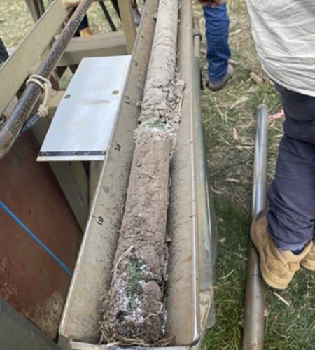
Pit Assessment And Face Preparation
Effective pit assessment involves cleaning the pit, avoiding shadows when photographing, and ensuring a straight and well-defined face. It’s important to describe and photograph samples before sampling, and having a pit sample tape is helpful. The use of description sheets, soil kits, and various tools is crucial for accurate soil characterisation. A systematic approach to pit assessment ensures quality data collection.
Data Collection In Soil Description
Data collection during soil description involves gathering information about landform, GPS location, surface structure, vegetation, land use, geology, and rooting depth. This information is vital for understanding the soil’s characteristics and its suitability for various purposes. Proper documentation and the use of relevant tools and techniques enhance the accuracy and usefulness of the data collected.
Field Testing And Soil Characterisation
When performing soil characterisation, it’s important to record information for each layer or horizon, including depth, texture, colour, pH, acid reactions, and other relevant tests. Sub-sampling may be required for thick layers. A well-structured description sheet can guide the process. Proper testing provides valuable insights into soil characteristics and their suitability for various purposes, such as agriculture or horticulture.
Understanding Soil Layers And Carbonate Classification
Examining soil layers and classifying carbonate content is key for assessing soil health. Different classes of carbonate layers have implications for drainage, root growth, and soil toxicity. Understanding the carbonate content helps in understanding root growth patterns. It’s an important aspect of soil characterisation, particularly in regions like South Australia.
Chemical Analysis And Soil Results
After field testing, chemical analysis provides insights into soil fertility and potential limitations. Tests cover pH, salt toxicity, exchangeable cations, carbonate percentage, fertility measurements, trace elements, organic carbon, and more. These results help in understanding the physical and chemical barriers to root growth, drainage characteristics, and overall soil health. The data aids in making informed decisions for land use and management.
Accessing Soil Data And Resources
There are various resources and data available for soil characterisation and analysis. These resources include the Australian Soil Classification Handbook (‘The Red Book’) and Munsell colour charts for consistent colour assessment. Additionally, online platforms like Nature Maps, Data SA Environment, and Soil Sites SA provide valuable soil information, including field descriptions, chemical data, and risk assessments, making it easier to access and utilise soil information for improved land management and research.
What To Look At
The South Australian Department for Environment and Water list the following soil features of greatest importance for South Australian conditions, land use and management:
- Soil constituents
- Soil fertility
- Toxic elements
- Soil structure
- Drainage
- Salinity
- Soil carbonates
- Soil depth
- Water holding capacity
- Erosion
More information on each of these features can be found here: The Soils of Southern South Australia – Summary of Major Soil Features.pdf (environment.sa.gov.au)
Recording location, landscape characteristics, and sampling depths are important for comprehensive soil profile descriptions.
Soil pit analysis can provide valuable background information for farmers and soil scientists. Choosing the right location, orientation, and understanding soil material behaviour can lead to better insights into soil structure and compaction, aiding in improved crop management.