The Soil CRC recently announced an additional $800K funding for the continuation and further development of the Visualising Australasia’s Soils (VAS) portal, which is contributing to a legacy of soil data in Australia. The project began in 2019 to provide Soil CRC participants, and the agricultural industry more broadly, with access to data, information and knowledge on Australasian soils.
The first phase of the project wrapped up in 2021, delivering a dynamic web-based portal that brings together a large array of reliable soil datasets from government agencies, industry and grower groups, and individual farmers.
Project Leader Associate Professor Peter Dahlhaus from Federation University said this data can be interrogated to provide insights into local soil types and constraints, which can help inform soil management practices.
“The key objectives of VAS are to motivate soil data custodians to make their data findable, accessible, interoperable and reusable (FAIR), and align with other national and international soil research data initiatives to maximise discovery and reuse,” he said.
Phase 2 (2021-2024) is almost complete and has added greater functionality to the VAS portal, including a self-serve data management system, improved filtering and reporting, seamless interoperability with the Australian National Soil Information System (ANSIS) and the inclusion of soil sensor data.
Associate Professor Dahlhaus said the final phase (Phase 3) aims to transform VAS into an enduring component of an Australasian soils knowledge system that is both self-sustaining and inherently useful for research and education.
“This will be complemented by the development of a governance model, which will include data governance and stewardship guidelines for managing VAS beyond 2027,” he said.
“Phase 3 will also harness artificial intelligence to add value to soil performance data, and enhance the reporting of soil quality, function and target values for high performance soils,” he said.
Phase 3 is a collaboration between Federation University, the University of Newcastle and a Community of Practice initially involving Soil CRC participants across Australia including Burdekin Productivity Services, North Central CMA, Riverine Plains, Southern Farming Systems, Western Australian No Till Farmers Association (WANTFA) and West Midlands Group. More participants are expected to join as the project develops.
Revamped web portal
The project team at Federation University’s Centre for eResearch and Digital Innovation (CeRDI) recently launched a new-look VAS interface to improve the user experience and provide additional resources and user guides.
“The revamped platform also enables the integration of future technologies and can accommodate expanded soils data,” Associate Professor Dahlhaus said.
“The site will continue to evolve during the next phase of the project, as more information, data and functionality is integrated into the system.”
A link to the portal is available on the Soil CRC website.
Southwest Victoria soil monitoring use case
Soil CRC participant Southern Farming Systems, together with the Corangamite and Glenelg Hopkins Catchment Management Authorities in southwest Victoria, recently shared soil health monitoring data for their regions. The time-series data is now publicly available on the VAS portal.
Associate Professor Dahlhaus said this data series showcases the ability of VAS to provide soil data with repeat measures for various profile depths at the same site.
“To facilitate reciprocity between VAS and other Australian soil data ecosystems, these data will also be made available to the Australian National Soil Information System (ANSIS),” he said.
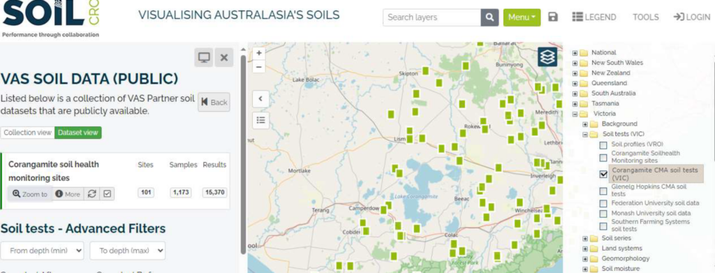
Screenshot of the VAS data portal showing Corangamite soil health monitoring sites
VAS and ANSIS
Associate Professor Dahlhaus said he is often asked about the differences between the VAS portal and the Australian National Soils Information System (ANSIS), an initiative being developed under the National Soil Action Plan.
In a nutshell, the VAS project serves the Soil CRC and its partners, mainly farmer groups, catchment management authorities, and researchers, whereas ANSIS was developed by the Australian Government as a national inventory of soil data and soil monitoring.
ANSIS does not store any data. It has established interoperability with Tier 1 (Australian Government and CSIRO), Tier 2 (state government) and Tier 3 (e.g. VAS) soil data repositories and provides the ability to search and discover this soil data via ANSIS.
VAS supports Tier 3 soil data custodians (Soil CRC and participants, NRM bodies, universities, and research agencies) in managing their soil data collections. It is an online soil data aggregator which a VAS user can log into to self-manage their own data, and upload, filter, visualise and download selected data. Users choose if they want to share their data and set the licensing conditions for how it is shared.
Both the VAS and ANSIS systems can interoperably share data with each other (and any other systems that serve and consume internationally standardised soil data) through access controls and trusted mechanisms that respect the data owners’ rights and licensing requirements.
VAS federates soil related datasets that have been created and managed by industry groups, community groups and individuals, government agencies, universities and non-government organisations and maps them to international data-exchange standards information.
It also accesses publicly available soil data from open repositories such the ANSIS Tier 1 and Tier 2 data and includes other soil data that has been made openly available by the data custodians, such as that on the Soil Health Knowledgebase.
There are many similarities in what VAS and ANSIS aim to do, such as make Australian soils data findable, accessible interoperable and reusable (FAIR). Both systems aspire to enable their users to make better decisions by providing more and better data.