A vast amount of disparate soil data exists in Australia, both in the public and private sectors. But how can we best access and apply this data to support decision making that leads to best practice soil management? Enter the Soil CRC’s Visualising Australasia’s Soils (VAS) project led by Federation University.
Beginning in 2019, the project set out to provide Soil CRC participants with access to data and information for knowledge on Australian and New Zealand soils. Its aim is to make the data Findable, Accessible, Interoperable and Reusable (FAIR), and align with other national and international soil research data initiatives to maximise discovery and reuse.
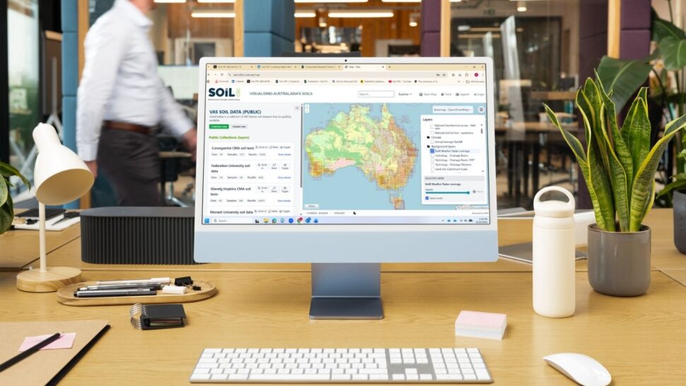
Phase 1 (2019–2021) of the project delivered a dynamic web-based portal that brings together a large array of public and private soil datasets for use by the Australian agricultural industry.
Phase 2 (2021–2024) added greater functionality to the VAS portal, including a self-serve data management system, improved filtering and reporting, seamless interoperability with the Australian National Soil Information System (ANSIS) and the inclusion of soil sensor data.
Now in its third and final phase, ‘Visualising Australasia’s Soils: Building a legacy’ (2024–2027), the project seeks to transform the VAS portal into an Australian soils knowledge system that is both self-sustaining and inherently useful for research and education.
Project leader Associate Professor Peter Dahlhaus from Federation University said Phase 3 is delivering a governance framework, business case and clear pragmatic value propositions for end users. Artificial intelligence is being harnessed to add value to soil performance data, and improve the reporting of soil quality, function and target values for high performance soils.
“During this phase, we have rolled out a series of upgrades and improvements to the VAS portal to enrich the user experience,” he said.
“We’ve introduced substantial enhancements – new tools, improved features, updated resources, and clearer information – designed to make the portal more intuitive, seamless, and easier to use.”
Planning for VAS beyond the Soil CRC is already well underway, to expand its use and ensure the ongoing success of the platform.
“The VAS project team will continue to build the long‑term legacy of VAS over the next 12 months and share its value with a broader audience,” A/Prof Dahlhaus said.
Read on to learn about the latest improvements and to find out what comes next.
New and enhanced content
The reconfigured VAS website has been designed to make navigating and accessing information easier than ever.
“New content ‘cards’ now guide users directly to key areas of the site, making it simple to locate the most popular and frequently used resources,” A/Prof Dahlhaus said.
A major addition to the site is a section dedicated to the VAS technical build and supporting research activities, providing a clear overview of the technologies, systems, and global connections that underpin VAS.
A/Prof Dahlhaus said research continues to be a critical pillar of the VAS project.
“A growing collection of reports, conference papers, presentations, and journal articles now document the VAS journey through a research lens and can be accessed via the portal,” he said.
A new project timeline has also been created, showcasing achievements across each of the three phases of VAS since its initiation in 2019.
“The timeline highlights key milestones and demonstrates the significant progress made over the life of the project.”
Technical improvements
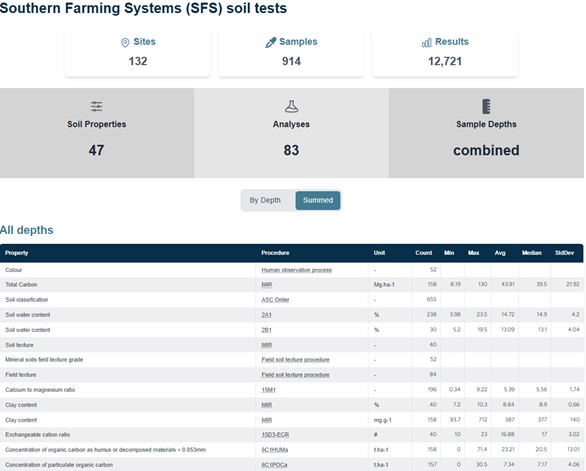
For various reasons, some partners have elected not to publicly share their soil data. This has made it difficult to visualise the breadth of soil data contained in VAS. However, the introduction of a VAS (meta)data catalogue offers a technical solution by providing high level descriptions of available datasets.
“Users can now see who owns the dataset, the state their data comes from and the years that their data span; the number of datasets, sites, samples and results; and whether the dataset is locked or unlocked,” A/Prof Dahlhaus said.
Users can access more detailed statistics for unlocked (publicly accessible) data, as shown in the example below.
New features in the VAS map portal provide improved soil information at both national and state levels. For example, users can now easily access links to the Soil and Landscape Grid of Australia and can create a report of modelled soil properties for a selected location.
“To further enhance the usefulness of VAS, we have also improved the public datasets, with soil series maps now linked to the explanatory notes, where they exist,” A/Prof Dahlhaus said.
VAS Business Plan and Governance Framework
To inform the business plan, the project team collected feedback from project partners to explore their experiences with both VAS and soil data management more broadly. Analysis of the insights has uncovered opportunities for the further development of VAS beyond the Soil CRC.
A proposed socio-technical data governance framework has been developed to guide data stewardship and ensure the longevity of FAIR data, rights of access and use, and trust. The VAS Business Plan and Governance Framework have been prepared and are being reviewed by the Soil CRC Board.
Social research insights
The project team conducted social research to examine the perceptions, role and application of VAS by project partners, and published the findings in a journal paper last year.
The research identified that there is broad agreement amongst project partners regarding the contribution of VAS, and anticipated expectations for soil data sharing and management using the portal. However, data custodians remain reluctant to openly share data for a number of complex reasons. These challenges are being address under Phase 3 of the project.
Collaboration at its core
A/Prof Dahlhaus said the VAS project partners and data custodians are core to its success.
“The continued involvement of our partners helps us maintain VAS as a leading interoperable spatial knowledge system for soils-related data across Australasia.
“Their efforts to upload and share their soil data, continue to use the system, contribute to its improvement and promote its value within their networks is what makes VAS valuable.”
The project team is working with VAS partners to showcase how they are using the portal and what benefits they have received.
“I’m excited about what we can build together as an enduring and important component of the national soil data systems. I hope the next 12 months will see us take major steps toward the long‑term vision for VAS,” A/Prof Dahlhaus said.
What comes next
A Community of Practice made up of the participating grower groups is contributing to the identification of key use cases. These are being developed to demonstrate the value of VAS outcomes for project partners and industry.
A/Prof Dahlhaus said further enhancements are being made to the VAS portal, including improvements to the self-service system and public (open) datasets, and the addition of self-paced education modules.
“Ongoing research will assess VAS’s contribution as a federated soil data knowledge system. The research will provide evidence that will inform and guide future data federations,” he said.
Find out more
Project partners
- Bioeconomy Science Institute
- Birchip Cropping Group
- Burdekin Productivity Services
- Central West Farming Systems
- Facey Group
- FarmLink Research Ltd
- Liebe Group
- MacKillop Farm Management Group
- North Central Catchment Management Authority
- Riverine Plains
- Southern Cross University
- Southern Farming Systems
- University of Newcastle
- University of Southern Queensland
- University of Tasmania
- West Midlands Group
- Western Australian No-Tillage Farmers Association
- Wheatbelt Natural Resource Management
- Wimmera Catchment Management Authority